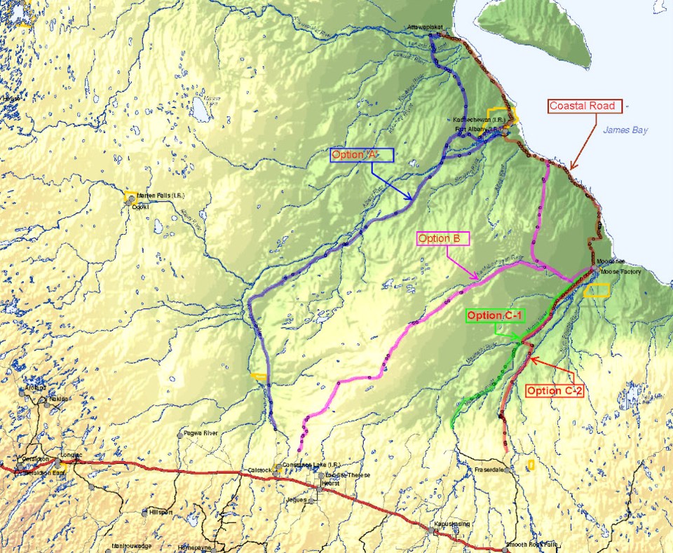
Two provincial cabinets promised chiefs of Mushkegowuk Council that it will "explore" the idea of a permanent, all-season, road linking four remote communities on the James Bay coast to the start of the provincial road network.
That was one of the topics of dialogue that came out a Dec. 3 meeting, deemed "historic," between Mushkegowuk leadership and the Ontario government held in Timmins.
"Responsible development" was the theme around the discussion tab attended by chiefs from Missanabie Cree, Chapleau Cree, Taykwa Tagamou, Moose Cree, Kasechewan, Fort Albany and Attawapiskat First Nations and the government side, Northern Development, Mines, Natural Resources and Forestry, and Indigenous Affairs Minister Greg Rickford and David Piccini, Ontario's Environment, Conservation and Parks Minister.
The government and Mushkegowuk Council made a ''commitment" to re-establish a Treaty 9 Round Table. The forum will "discuss areas of mutual interests and opportunities."
Ministers Rickford and Piccini also committed to exploring an all-season road to the western James Bay coastal communities through a First Nations-led environmental assessment process.
Resource revenue sharing was also discussed and the province is apparently willing to consider its role in Mushkegowuk's project for a National Marine Conservation Area.
On the Mushkegowuk road, the council posted a summary of a report and map on its website, identifying one coastal road and four southbound road scenarios following the Albany River, Kwata River, Mattagami River and the Moose River-Ontario Northland Railway right-of-way.
The proposed roads, ranging in distance between 547 kilometres and 676 kilometres would link the communities of Attawapiskat, Fort Albany, Kashechewan and Moosonee before turning southwest to reach various points where roads begin near Highway 11.
The southern terminus for two roads would be near Hearst at Constance Lake and Fushimi Lake; two other roads would end just north of Fraserdale, near the Harmon Generating Station and Otter Rapids.
These proposed roads would be well east of Marten Falls and Webequie First Nations and the proposed community access and industrial roads to the Ring of Fire, now undergoing provincial environmental assessments.
Some Mushkegowuk communities - particularly Attawapiskat and Fort Albany - recently came out strongly against such mining-related development.
In a Nov. 29 letter penned to Premier Doug Ford and Rickford, Attawapiskat Chief David Nakogee and Fort Albany Chief Robert Nakogee accused the Ontario government of acting in "bad faith" in its consultations with area First Nations. They went after the premier for making statements that indicate the government is willing to take unilateral action on Far North development.
They accuse Queen's Park of conspiring with the federal government to "water down" the new Regional Impact Assessment and introduce a process that is "not co-led" by First Nations.
In a statement, Mushkegowuk Council Executive Director Ernest Beck called the meeting a "tremendous step forward" in their commitment to protect their traditional lands. They intend to take the ministers' "commitments to partnering on several fronts seriously, and we will pursue them with all of our available resources."
Rickford called the dialogue "positive and constructive" and looked forward to partnering with the Chiefs on opportunities that "produce positive outcomes for First Nations communities."
Piccini praised the "tremendous leadership" of Mushkegowuk Council in seeking protections of the James Bay coastal and marine ecosystems. He seemed eager to partner with the communities to consider an Indigenous-led environmental assessment for an all-season road.
Pirie said it was the City of Timmins' responsibility, as a "vested partner in the economic success" of the region, to provide a forum for "collaborative discussions" to spur both resource development and conservation efforts for this coastal area.


